Front:
HELENA
BUTTE
TELLOWSTONE
PORTOLLA
WHNE UCH
A LAKE Сте
B. N30908
SONDS 000MET
ETATS
_col
OMAH
DOROVILLE
DENVER
RISVILLE
COLORADO SPRINGS
4 ST JOSEPH
ACRAMENT
SUGAR CITY
PUEBLO
KANSAERSON Cm
ST LOUIS
DOMIE
NOUDNI ONV:9
HOT SPRINGSM ILE ROCK
MEMPHIS
SAN FRANCISCO
URANGO E
D
FORT WORTH
LAREDO
LOS ANGELES
SAN DIEGO
GALVESTON
NEW ORLEANS
SAN ANTONIO
NAMA CANAL
O
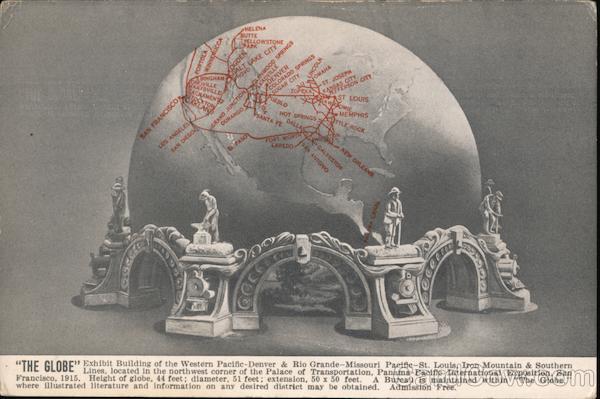
"THE GLORE" Exhibit Building of the Western Pacific-Denver & Rio Grande-Missouri Pacific-St. Louis, Iron Mountain & Southern
· Lines, located in the northwest corner of the Palace of Transportation, Panama-Pacific International Exposition, San
Francisco, 1915. Height of globe, 44 feet; diameter, 51 feet; extension, 50 x 50 feet. A Bureau is maintained within “The Globe.”
where illustrated literature and information on any desired district may be obtained. Admission Free.
Back:
Place Stamp
Here
Post Card
United States
and Canada,
One Cent
Foreign
Two Cents
9 In the PALACE OF TRANSPORTATION, Panama.
Pacific International Exposition, San Francisco.
On the outside is a relief map of North America, showing the
territory served by the lines of the Western Pacific-Denver & Rio
Grande-Missouri Pacific-St. Louis, Iron Mountain & Southern.
Within is displayed a series of twenty-four illuminated models of
cities and towns, mining camps, agricultural districts, industries and
notable scenic points located on the lines of the railroads named.
