Front:
The TENNESSEE VALLEY
Paducah.
K Y.
Nashile
Nari
NORRIS DAM
N.
Kumille
Asherill
EAT SMOEY MTS
PARK
С.
PICKWICK
LANDING DAM
CHICKAMAUGA DAM
FOWLER
BEND DAM
WHEELER DAM
ihattanoe
GUNTERSVILLE
DAM
WILSON DAM
A.
A LA.
Birmingham
Ailanta
10 20
Kala Milea
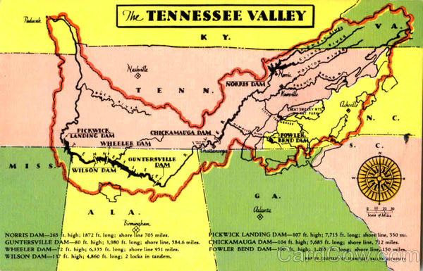
NORRIS DAM-265 ft. high; 1872 ft. long; ahore line 705 miles.
GUNTERSVILLE DAM-80 ft. high; 3,980 ft. long; shore line, 584.6 miles.
WHEELER DAM-72 ft. high; 6,335 ft. long; shore line 951 milea.
WILSON DAM-17 ft. high; 4,860 ft. long; 2 locks in tandem,
PICKWICK LANDING DAM-107 ft. high; 7,715 ft. long: shore line, 550 mt.
CHICKAMAUGA DAM-104 ft. high; 5,685 ft. long; shore line, 712 miles.
FOWLER BEND DAM-300 ft. high; 1,265 ft. long: shore line, 150 miles.
MAP BY COUNTESY OF TENNESSEE VALLEY AUTHORITY
Back:
26196N
Pa
The TVA area embraces more than 40,000 square
miles and encompasses the drainage area of the
Tennessee River and its tributaries in Tennessee and
portions of six other states Virginia, North Carolina,
Geoggia, Alabama, Mississippi and Kentucky. More
than 2,000,000 people live within this area. All of the
dams shown on the map, with the exception of
Fowler Bend Dam, are now under construction or
completed.
BY
STANDARD
NEWS AGENCY, KNOXVILLE
NN
100
